
Category (en-gb)
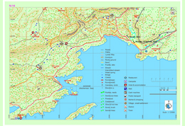
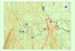
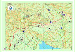
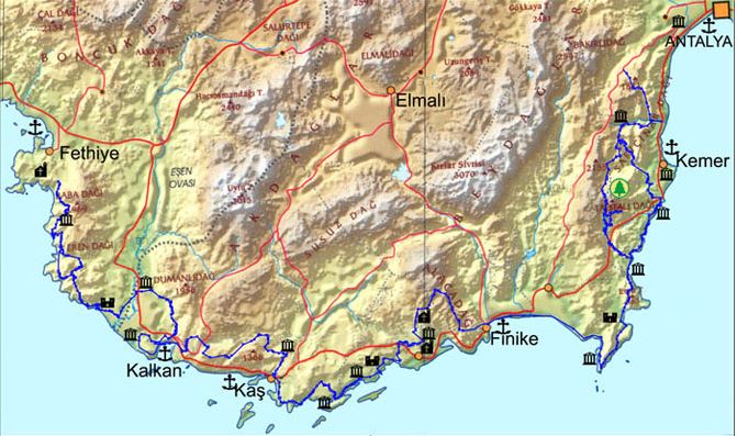
Simena – Kapaklı – Andriake
The road advancing from between the houses behind the square of the Üçağız location leads to the dockyard after 2-3km of earth road. The road winding along the coast where the dockyard is located advances across the plains where there are only a few houses, fields and a cemetery and a water fountain. After reaching the cove, the road splits up from the cove by passing through the ruins overlooking the cove.
Lycia road path advances with a slight upward slope until Kapaklı village, but without entering the residential region, the road starts to re-descend from below the village and reaches the sea cost. You can reach Andriake from the gravelous beach and you can get to the highway if you take the narrow pathway to the right after passing by firstly the wooden bridge and then the archeological settings in Andriake. From this place, you can catch a sight of the St. Nicholaos Church in the district of Demre and then get to Myra archeological settings.
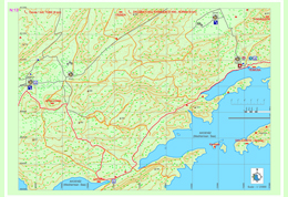
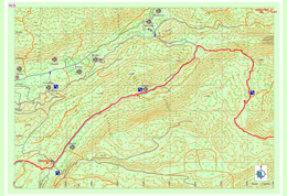
Boğazcık – Üçağız
From the entrance to the Boğazcık settlement towards the right side through the Lycian road it is possible to obtain drinking water, food and even accommodation from the village homes. Lycian road goes towards right from the entrance of the village and left from above the hill and goes towards the hill on which Appollonia archaeological settlement is located.
After following the asphalt road at the slopes of the hill on which ruins are located for a short time, it turns right and after descending from stony lands and passing from pathways of red soil among the olives, Aperlai archaeological settlement could be reached. It reaches to the other lagoon at east after going on as parallel to the ruins from red colored fields through a gap between the lagoon northeast of Kekova Island and the lagoon in front of the ruins. From here towards the north hills one could descend from a hill overlooking Kekova and Üçağız after passing some flat areas on which there are large trees and enjoyable pathway.
Limanağzı – Boğazcık
Passing from the neck of the peninsula starting from the point where Limanağzı is located and after a mild climb, Lycian road goes on from the seaside and continues parallel to the shore with sharp white stones and reaches to Çoban bay. By descending from the hill just above the bay again Fakdere region could be reached. At the end of the cape located south of Fakdere, there are the remains of the ropes used in unearthing the world’s oldest sunken ship which is exhibited in Bodrum museum.
At the eastern end of the bay in which Fakdere is located there is an old cistern and ruins. From the guardhouse in Fakdere drinking water could be obtained if necessary. One could reach after climbing the hill on the east and first from a dirt road and then from a pathway which consisted of round, carstic lime stones and red soil to a region called Üzümlü pier among the rubble stones just next to the sea with olive trees. The road goes parallel to the shore and goes on through a bay adorned with white very sharp marbles and under carob trees.
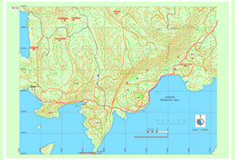
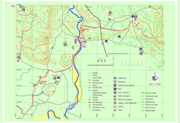
Kaş – Limanağzı
Lycia road goes from Çukurbağ towards south and descending from a terrace overlooking Kaş district in a perpendicular way and passes from Kaş settlement. Kaş district is a center in which needs such as public transportation, market, bank, accommodation etc. can be met. For the ones who will go on towards Limanağzı direction, they should move on with keeping in mind that there is no other settlement until Boğazcık – Kılınçlı settlement for obtaining the needed resources.
The road goes on towards the Büyükçakıl beach from an asphalt road parallel to the sea inside Kaş district and after passing the beach the road turns right and climbs towards the settlement area and then from there goes on as a dirt road. Before coming to Limanağzı area first Sebeda archaeological settlement is seen and after some little side passes with the help of the ropes in front of rock tombs overlooking the sea, some needs can be obtained from the businesses in Limanağzı bay. The pathway goes on among fields, stony areas and narrow dirt tracks in some parts and then turns towards the seaside again after a couple of kilometers from Limanağzı.
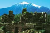
LİMANAĞZI (SEBEDA)
In this region which is named Bayındır port today the name of the town which contains Bahtsız and Kavgar hills is known as Sebeda. Town is set up around a secured port and it is a little farm settlement belonging to the Lycia period with its oil extraction workbenches, cisterns, rock tombs, sarcophaguses. There are Lycian type room tombs cut in natural stone dating back to 4th century B.C. at the slopes overlooking the sea of Bahtsız hill and at seaside there are the remains of buildings which can be related to the port usage and estimated to had been used as warehouses. At the hilltop there is an open air temple which is formed with the flattening of a natural stone on which there are sarcophaguses and niches. The ruins of the building over the Kavgar hill which can be reached with a pathway thought to be used in ancient times, is thought to be a watchtower. There are tombs around the watchtower belonging to Lycia and Roman period some of which containing inscriptions over them.
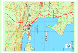
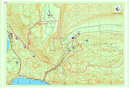
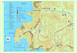
Çukurbağ – Pınarbaşı
The road which goes among the thorns in some places until Phellos had become extremely non-visible at some points due to the new road construction works. After a gentle slope towards the hill, the ruins of Phellos can be seen and the n the pathway takes us towards the entrance of the city. It turns towards Çukurbağa without entering into the city. It then continues to descend perpendicular to Çukurbağ for a couple of kilometers. From the village mosque one could reach to village center.
There are no markets in the village but there are drinking water wells in multiple locations. Lycian road goes inside of Çukurbağ and after passing long flat areas and fields reaches to a point overlooking Kaş district from a hill. The ruins registered with the name of Pınarbaşı at southern together with Pınarbaşı settlement without leaving from the road when descending towards Çukurbağ down from Phellos.
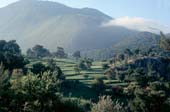
Gökçeören – Gökdere
Accommodation and eating-drinking needs are being supplied by the local people in Gökçeören. The road goes on the asphalt for a while starting from Gökçeören and later from a dirt road goes on as parallel to river bed. After a long descend with a gentle slope the sight of kara dere (kara river) which flows both in summer and winter, a climb starts towards the hill across the river. After a couple of hours of climb there is a flat area and then there is a couple of abandoned houses.
Then a place which is appropriate for camping and with drinking water and also with a large sycamore tree can be seen. After this point Lycia road signs were erased mostly due to the road construction work. The road goes on sometimes as dirt and sometimes as pathways. If one is to go 7-8km from the pathway from Hacıoğlu settlement to northeast, Kandyba ancient settlement can be seen.
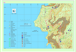
Kalkan-Bezirgan-Sarıbelen
One could proceed 3-4 km through the asphalt from Akbel to Bezirgan with a view of Kalkan. By turning left from the old water cistern on the road, an inclination begins towards the hilltop from the stony pathway with zigzags. This could be a steep and tiring climb. After the peak and walking from stony pathways, old but still usable granaries can be seen. You can proceed on the asphalt until Bezirgan village square.
Drinking water can be obtained after Kalkan district only from the fountains in Bezirgan. Also there is a market at the center for basic shopping needs. Then there starts a climb from Bezirgan towards the main road. After proceeding towards the TV transmitter from the dirt road near the main road, and after walking for a while you can pass to pathway from the dirt road and then the descend starts from among the shrubberies. Lycia road signs were partly erased in this section.
Akbel – Delikkemer – Patara
The road which goes on the asphalt reaches to Akbel after 1 km south from the İslamlar (podamya) settlement. When you go right from the cemetery and left from the first opening when going towards the mosque and then take the first right from the opening, the pathway goes straight from near the school and then when you cross the Antalya asphalt you see the Delikkemer sign. The pathway goes on asphalt from Akbel to this point and then goes on with a view of Kınık-patara valley for 6km inside shrubberies.
When reached to Delikkemer the road splits into two. One goes towards Kalkan and the other goes towards Patara as parallel to the Delikkemer. When passing near Kemer the Patara table is shown. At the dirt road on left the Lycia road signs are partly erased. At the left side Fırnaz bay and Kalkan view can be seen. After going straight for 2-3 kilometers the road goes on in zigzags and reaches to Pınarkürü.
Çayköy-Üzümlü-İslamlar
When going towards the right from the three lane intersection south of Çaydır Settlement, the road goes on to first a graveyard and then when continued to an olive grove towards the top of the hill. An old Roman bridge draws attention in the area. Lycian pathway reaches to a village road over the Çayköy settlement. After a while when the pathway starts again it goes on parallel to the waterways.
After a second Roman bridge has been passed it goes on from a dirt road under the pine trees. At the end of the forest are you should pass from an area with dense thorns. Pants or legging use is suggested especially in this area. Lycian road which goes on partly as natural pathway, and at some points from the asphalt, reached to Akbel after a couple of kilometers of descend from İslamlar settlement.
In this map section market is only located in Üzümlü settlement on the Lycian road. In the İslamlar settlement there is a business providing accommodation and also there is another market which is not so close to the Lycian pathway. After 2km from Üzümlü settlement and 4 km, drinking water can be obtained from two different fountains. Going upwards from the river bed in the Üzümlü settlement and deviate from the Lycia road, there are four different areas of remains in the river bed until Yeşilce settlement.
Kumluova-Letoon-Kınık-Ksantos-Çavdır
Before coming to Kumluova, the road goes on through the sandy land covered by eucalyptus trees and shrubberies, then goes on to the left from the location of the fountain. It is not recommended to drink from this fountain. The pathway crosses the bridge after a while and goes on towards the Kumluova – Gerenovası settlements which contain lots of greenhouses. From the road, Letton ruins can be seen. After the Letoon ruins, when going towards east, it goes on until the edge of Eşen River.
It also goes on to north parallel to Eşen River. Karaköy and from the other side of the bridge Kınık settlements can be seen. This is the first settlement which contains a bank or ATM access from Fethiye on the Lycia road. Across the bridge at the left side, if one goes on upside from the asphalt road from passing in the middle of the bazaar area Xhantos ruins can be seen. After the ruins the pathway goes on parallel to the asphalt road in the forest. Lycia road signs in this area were erased. When you go on to east parallel to the asphalt road, you can see the interurban road intersection.

Belcekız – Gavurağılı – Kumluova
The Lycia road splits towards right after a couple of kilometers from the dirt road which splits towards southeast, on a flat area with its red soil, ancient olive trees, carstic limestone and plants indigenous to the Mediterranean seems just like a man made ornamental garden and elevates through high pine trees towards a channel after a region called Belcekız.
After the channel it starts to descend from a steep slope in zigzags. In this region in which the characteristic Lycia road signs are erased, if one goes on to descend from the slope towards southeast, after a while they can reach to the flat areas at the west of the Gavurağılı settlement. A long slope descends ends after passing a stone masonry pathway. The pathway which goes on for one km among the trees and fields, reaches to Gavurağılı settlement.
Gey – Bel ; Boğaziçi – Sidyma
In the Alınca settlement the pathway of Lycia road which is separated from the asphalt road, goes towards south along the slope overlooking the sea at the west side of the Eren Mountain. The pathway going downwards from the Üçkeçi region in which there are bee hives to Cennet Bay, separates from the Lycia road. The pathway which goes on towards south for a while, reaches to a flat valley on which there are stone terraces on some parts.
One can reach to Pirate bay with the pathway separating towards right after the first cistern to be seen here. Along the Pirate bay and the cape located in south Kalabantia archaeological settlement can be seen. If one goes on from the marked Lycia road without leaving, this Lycia road splits into two before a village home, and at the right side it goes on from Gey and Yediburunlar towards Bel settlement.
Faralya – Kabak- Alınca
The Lycia road which goes on downward from Kirme settlement, reaches to the asphalt road of Faralya settlement after passing near large and small water sources. Faralya village settlement is located at a very special location in terms of flora, on a slope overlooking the south at the mountainside of Babadağ and just above the valley of butterflies. It contains most endemic plant types.
The minibus coming from Ölüdeniz, reaches to Uzunyurt or even Kabak settlements after passing from Faralya. At Faralya there is a market and shopping opportunity. Accommodation in camp, bungalow and Mediterranean type hotels made from stone is available. Before passing Faralya if you turn towards right from the main road, the peerless view of the valley of the butterflies can be seen. There is even a pathway reaching to the camp site located down at the valley downwards from this turn. The descent is made by hanging to the ropes set on crags. This is extremely dangerous for the people with heavy loads and amateur walkers.
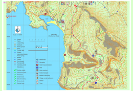
Ovacık-Kirme (Kayaköy)
Even though the Lycia road is accepted officially as being started at the south of Ovacık town, at the crossroads of an asphalt road which is located on the east (mountain) side of a road as parallel to Ölüdeniz road; there are other archaeological settlements such as current Fethiye and previous name Termessos which was accepted as the western border of known Lycia civilization and Kayaköy which was known as Karmylassos.
You can reach to Ölüdeniz Lagoon after a walk with view of both forests and sea and Kayaköy after crossing the pathway which was signed with different colors as a walking road but not as Lycia road, which has stone masonry on some of its sections between Ölüdeniz and Karmylassos (Kayaköy) which is one of the biggest settlements of Lycia. From there after a break in Ölüdeniz town center from vehicle road, another pathway which goes South at the end of Belcekız beach on the road located at the mountainside and linking to Lycia road located above, you can reach Lycia road.
Lycian Ancient Cities
{load_gf_map 1}
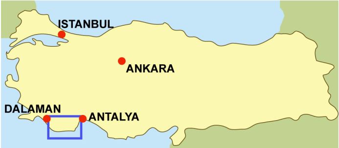
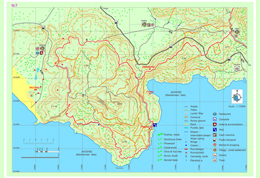
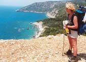
The Lycian way is a 509 km way-marked footpath around the coast of Lycia in southern Turkey, from Fethiye to Antalya. The Lycian Way is a coastal walk and mild temperatures mean it can be walked throughout the winter months.
According to the Sunday Times the Lycian Way is one of the ten most beautiful long distance hikes of the world.
Shopping in Kaş
Lycia’s History - A Struggle For Freedom
The history of Lycia is a story of fierce struggles against those who sought to invade and dominate it, as it was a very desirable region. It appears that Greek efforts to colonize Lycia during the first millennium B.C. were largely unsuccessful even though there were several Athenian expeditions.
 |
The first recorded instance of Lycian resistance fighting occurred around 540 BC when the Persians under the commander Harpagos overran all Asia Minor during the rule of Cyrus II (The Great). The Persians attacked the Lycian capital city of Xanthos and the Xanthosians put up a heroic fight. In the end however, they chose mass suicide over surrender. The men of Xanthos gathered their wives, children and possessions in the acropolis and set fire to all before rushing out fighting to die to the last man. Herodotus of Halicarnassos reports: |
"The Persian Army entered the plain of Xanthos under the command of Harpagos, and did battle with the Xanthians. The Xanthians fought with small numbers against the superior Persians forces, with legendary bravery. They resisted the endless Persian forces with great courage, but were finally beaten, their womenfolk, children, slaves and treasures into the fortress. This was then set on fire from, below and around the walls , until destroyed by conflagration. Then the warriors of Xanthos made their final attack on the Persians, their voices raised in calls of war, until every last man from Xanthos was killed."
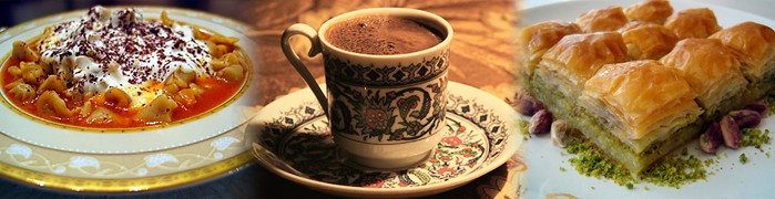
One of the greatest cultural legacies of the Turks who played a major role in the beginning and development of the history of civilization and undertook the first great migration bringing along their values and culture to the Anatolian lands is the Turkish cuisine.
The Turkish cuisine, which had originated from the blending of the Asian, European, Middle Eastern and African cultures and evolved under the influence of the Seljuk and Ottoman Cuisines over the centuries, offers thousands of various dishes and delicacies.
Turkish cuisine evolved long before the Common Era, during the times of hunting and gathering. To provide the hunters with delicious and savory food the women of the time developed various dishes by trial and error and discovered the spices that added flavor.
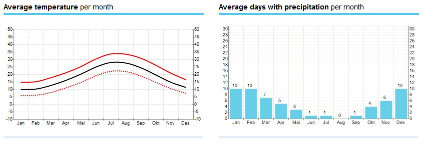
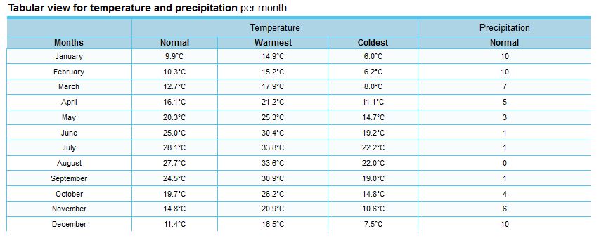
Average Weather in Kaş
Hot season / summer is in June, July, August .
Most rainfall (rainy season) is seen in January, February, October and November.
Kas has dry periods in April, May, June and July.
On average, the warmest month is July.
On average, the coolest month is January.
November is the wettest month.
June is the driest month.
Climate of Turkey
Surrounded by high mountains and open seas, Turkey is a cornucopia of natural wonders. Apart from that, Turkey is noted for its climatic diversity ranging from the Mediterranean to oceanic to continental climates.
The northern regions of Turkey have an oceanic climate whereas the southern areas are affected by a temperate Mediterranean climate. The continental climate reigning in the internal regions makes one experience four seasons in one day.
The southern regions which are popular among tourists particularly in summer and the central and northern regions of Turkey which are in demand rather in winter are popular for their cultural heritage as well as the variety of touristic and sports facilities.
Subject to a variety of climates, Anatolia is also rich in flora and fauna. The habitat of numerous varieties of flora and fauna alongside magnificent forests, Turkey, is worth visiting any season of the year.
Kas is the last county town located on the south-west cost of Antalya. Antiquity name of Kas was Antiphellos (facing Phellos). As written on ancient sources; Antiphellos means “the extension of Phellos on sea” or the “coast of Phellos (stony place)”. Antiphellos is now a village located on the north of Kas and called Cukurbag.


Subcategories
Accommodation Article Count: 0
Tours & Activities Article Count: 1
Tours, trips Article Count: 1
Boat Tours Article Count: 0
Trekking Article Count: 0
Blue Cruise Article Count: 0
Discover Lycian Article Count: 34
|
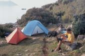
The Lycian way is a 509 km way-marked footpath around the coast of Lycia in southern Turkey, from Fethiye to Antalya. The Lycian Way is a coastal walk and mild temperatures mean it can be walked throughout the winter months. According to the Sunday Times the Lycian Way is one of the ten most beautiful long distance hikes of the world. The route is graded medium to hard; it is not level walking, but has many ascents and descents as it approaches and veers away from the sea. It is easier at the start near Fethiye and gets more difficult as it progresses. We recommend walking the route in spring or autumn; February-May or September-November; summer in Lycia is hot, although you could walk short, shady sections. The route is mainly over footpaths and mule trails; it is mostly over limestone and often hard and stony underfoot. On the first part of the route, and in Patara, Kalkan, Kas, Myra, Finike, Adrasan, Olympos, Cirali and Tekirova, you can stay in pensions or small hotels. On other nights, you may stay in a village house, or camp out. There are plenty of camping places with nearby water mentioned in the book; you do not have to ask permission to camp out.
Highlights of the Lycian Way include: |
|
Lycian Way Article Count: 31
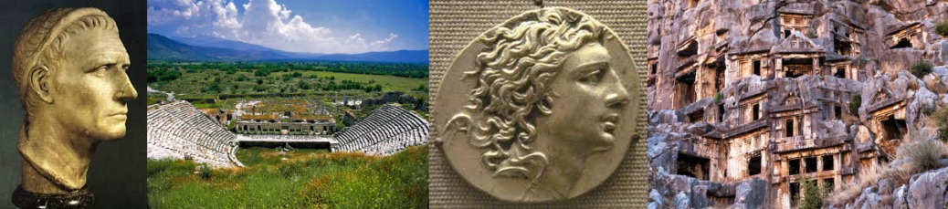
| Teke peninsula, which is located between the Antalya and Fethiye gulfs in the Mediterranean region, was named as Lycia in ancient geography. The southern border of the region is its coast to the Mediterranean Sea, while its eastern, western and northern borders changed throughout the history. According to the ancient writers, Beydağları which start from the west of Antalya and extend to southwest, Akdağ range and their extension to the northwest defines the northern border of Lycia. In the famous epic poem Iliad, Homer states that the Lycians, which were commanded by Glaucus and Sarpedon, supported the Trojans against the Achaeans. |
Lycia came under the dominance of the Persians after 545 BC and supported the fleet that was formed by the Persian King Xerxes for the conquest of Greece in 480 with 50 ships. The Persian occupation ended when Alexander the Great crossed the Bosphorus to Anatolia and defeated the Persians in 333 BC in the Battle of Granicus. After the death of Alexander the Great, Lycia came under the dominance of Ptolemaic dynasty in Egypt, which descended from the general Ptolemy, from the year 309 BC for 100 years; this is known to be the period in which Lycian language was forgotten and replaced with Ancient Greek.
The region has been ruled by the Syrian King Antiochus III between the years of 197 BC and 167 BC. Lycia received its independence from the Roman Empire in 167 BC. During this period, 23 cities united and formed the Lycian League, of which the capital city was Xanthos. According to inscriptions and ancient coins the League had its monetary unit.
Strabo states that the six biggest cities of the Lycian League were Xanthos, Patara, Pinara, Olympus, Myra and Tlos. The Miliarium Lyciae, which is the map of the Lycian region with distance units and routes connecting the settlements, is the oldest road map known. During the Roman Empire period, the League did not lose its function and reached maximum level of prosperity during this time. The city populations were around 5,000 and the total population of the region was approximately 200,000. The borders were pushed further as to include Kaunos (Dalyan) in the northeast.
Around the middle of 5th century, there were 34 cities ruled by the Proconsul of the Lycian State. The region between Demre and Kaş was the most populated area in Lycia. The amount of settlements per kilometer is nearly 30 in this region. Introduction of Christianity to Lycians did not occur until the visit of St. Paulus to Myra and Patara at his third missionary journey between the years of 53 and 57. Methodius of Olympus was the first known bishop of Lycia and he was executed in 312. The Byzantine period between 4th and 7th centuries was the period in which Christianity was adopted and many churches were built in the region.
One of the most prominent changes that occurred during the said period was the start of monastery settlement constructions, especially in the mountainous areas of Demre. Monasteries were very important points of power which had influence on the economic and public life. The monastery life in Lycia started as early as the 5th century. The fact that many large churches were built during the 5th and 6th centuries indicates that the population of the region was very high during the said period.
Most of the Lycian coast is formed of rocky terrain. This type of topography has allowed for natural harbors to be shaped at some locations. Strabo has expressed that the Lycian coastline is rough and difficult to pass through, while the harbor is very well-equipped. Maritime trade, which existed in the region since the Bronze Age, became diversified in the following periods and lasted until the Roman and Byzantine Periods. Purple dye, cedar wood, olive oil, wine and sponges are the key goods that are produced in Lycia. According to ancient sources, high quality and soft sponges can be harvested at Antiphellus and the area surrounding it. In addition, the quality of the cedar wood in Lycia, which is used in shipbuilding is rather high as well.
The harbors in Lycia can be named as Idyros, Phaselis, Corycus, Olympus, Posidarisus, Melanippion, Gagae, Phoinikos, Andriaca, Simena, Teimussa, Aperlae, Antiphellus, Kalamaki, Phoinike, Patara, Pydnai, Arymnessos/Perdicia, Calabantia, Karmylassos, Telmessus, Krya, Lisse and Lydai, respectively from east to west.
Of these harbors, Andriaca and Patara is distinguished from the others in that they possess political and economic power, in addition to being an internationals trade point. By virtue of its local traditions and distinctive architectural style, the region is the most interesting area in Anatolia; the cities of the region are generally located on the coasts and the valleys of Xanthos and Arycandus, which are considered to be the core of the region. Some of the texts that belong to the Lycians, who were known for having their own language and alphabet, were translated into modern languages; most of these are epitaphs.
The region of Lycia consists of cities of large, medium and small scale, port cities, military zones, farm settlements and towers. Most of the visible remains in the region belong to the Roman and Byzantine periods. The most encountered types of remains in the traditional settlements concentrated in the mountains are olive oil and wine workshops, and agricultural terraces. These rural settlements, in which most of the population lived, provided food for both themselves and the large cities.
The residential structures in Lycia are generally divided into four groups. The first group consists of adjacent residences in which each room has its own entrance. The second group is made up of stand-alone residences of one or two rooms in rural settlements. Both types of residences in these groups are generally two-storey houses that are located collectively or closely within walls of the settlement. The third group consists of single-storey residences with two to four rooms in agricultural areas of which some has courtyards, cisterns and workshops, while the fourth group is made up of residences of mostly rich people in rural areas, which are built as rooms surrounding a courtyard which is positioned in the middle.
Natural disasters and epidemics that occurred in the region have deeply affected the lives of those in the cities. The most prominent of these are the earthquakes that occurred in the years 141, 240, 385, and 529, and the plagues that happened in the year 542 and the period between 1346 and 1347. Due to the blights that were suffered in the coastal regions, the settlements in the inland areas came into prominence. Emperor Constans II fought the Arabians in 655 on the coast of Phoenix with the fleet he personally commanded. After being defeated, the Emperor managed to survive by way of the self-sacrifice of a young soldier. After this battle, the Arabians began navigating freely near the Mediterranean coasts.
In 802, the regions of Lycia and Caria were occupied by the Abbasids. During the 10th century, Lycia and the whole of the Mediterranean region were under the domination of the Byzantine Empire. Turks acquired access to Lycia after the Seljukian Sultan Kılıç Arslan II defeated the Byzantine army. After 1204, the whole of Lycia came under the domination of Turks.
Mountainbike tours Article Count: 1
Vacation Spots Article Count: 37
Kaş Article Count: 7
Olympos/Çıralı Article Count: 6
Kalkan Article Count: 6
Patara Article Count: 6
Kekova Article Count: 6
Demre/Hoyran Article Count: 6
Demre/Hoyran
Right_EN Article Count: 0
accordion-category-EN Article Count: 9

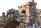
All pre-Greek peoples of Anatolia excelled in building monumental tombs associated with some form of ancestor worship; the Phrygians, Carians and Cilicians had their distinctive styles. The Lycians, however, developed this tradition to its artistic perfection. The landscape of Lycia is thoroughly marked by their strange, evocative and beautiful funerary monuments. Lycian tombs come in three major types. Visually the most striking are no doubt the rock tombs -more or less elaborate funeral chambers carved directly from the rock, usually into a cliff. The oldest of these are simple pigeon-hole cubicles of the sort best viewed in Pinara. More commonly, the graves are fashioned like the facade...
» Read more ..
If you really want to get a feel for southwestern Turkey’s Mediterranean coast, you have a great option: Hike the 300-mile Lycian Way, which stretches from Ölüdeniz to just shy of Antalya. Opened in 2000 as the country’s first long-distance trail, it’s been ranked one of the “World’s Ten Best Walks” by the Sunday Times. The route has many inland sections but provides plenty of awesome sea views from ridges and mountains high above the water, and also passes through plenty of ruins. It takes its name from Lycia, an ancient kingdom based in the region as far back as the 15th century BC. Budget 20-30 days to walk the entire trail, or explore shorter sections on day hikes out of towns like...
» Read more ..
There are 3 paragliding centers in Lycia: Oludeniz (near Fethiye), Kaş and Olympos.Oludeniz is one of the best places in the world for paragliding and in the last ten years has become a mecca for paragliders from all over the world. Incredible thermals and ideal conditions make for amazing flights from Babadag Mountain down to beautiful Oludeniz beach with its long stretch of white sand and turquoise blue water.The International Oludeniz Air Games Festival is held every year at Oludeniz beach. Lots of fun stuff to do and see.Kaş and Olympos also offers spectacular paragliding over the mountains and sea. Tandem paragliding isn't scary and is surprisingly relaxing. * Paragliding in the...
» Read more ..
Crystal clear diving in the Mediterranean Sea... The crystal clear sea offers excellent diving conditions with high amount of underwater life, visibility up to 40 meters and beautiful underwater rocky landscapes. You just won’t find coral reef here. In September/October the water temperature is ideally at 27°C!There are about 30 dive sites, reachable within 20/30 minutes from the port of Kas. The variety is quite impressive, you can go wreck-diving, cave-diving and you can swim through canyons and tunnels.If you are lucky, you might see dolphins, a Mediterranean monk seal, octopus or maybe even a seahorse (I did! but the poor thing with a dozen of divers taking pictures of it…). The...
» Read more ..
Kas is the last county town located on the south-west cost of Antalya. Antiquity name of Kas was Antiphellos (facing Phellos). As written on ancient sources; Antiphellos means “the extension of Phellos on sea” or the “coast of Phellos (stony place)”. Antiphellos is now a village located on the north of Kas and called Cukurbag. * Read More: What to know in Kaş * Restaurants, Cafés, Bars & Mayhanes in Kaş/ MAP & LIST * Hotels, Pansions, Camping Sites in Kaş / MAP & LIST
» Read more ..
A small peaceful Mediterranean resort and fishing town on the beautiful Turquoise Coast of Turkey, Kalkan has not been touched by mass tourism. More sophisticated than the usual resort town, Kalkan appeals to travelers looking for more than a “sun and sea” holiday. According to the Sunday Times, Kalkan attracts the kind of visitor who would also enjoy Tuscany or the Dordogne. The Guardian likens the town to “the Italian Riviera minus the poseurs.” Because of its great charm, Kalkan has a growing number of perennial visitors who say the town is the only holiday destination they would choose to visit repeatedly. There is simply no other town quite like Kalkan along Turkey’s coast. "Mouse"...
» Read more ..
Kekova, with its picturesque islands and intriguing sunken city* Read More: What to know in Kekova * Restaurants, Cafés, Bars & Mayhanes in Kekova/ MAP & LIST * Hotels, Pansions, Camping Sites in Kekova/ MAP & LIST
» Read more ..
* Read More: What to know in Olympos and Çıralı * Restaurants, Cafés, Bars & Mayhanes in Olympos and Çıralı/ MAP & LIST * Hotels, Pansions, Camping Sites in Olympos and Çıralı / MAP & LIST
» Read more ..
The name Patara stands for a marvellous 12 km white sandy beach which is classed as one of the most beautiful beaches in the world and for the ancient ruins of the ancient town still partly buried under the sand. The beach is also a nesting place for turtles and is therefore environmentally protected. The ancientcity of Patara, the birthplace of St.Nicholas and the port where St.Paul changed ships on his way to Tyros is in recent years being carefully excavated by Prof. FahriIşık. Patara used to be the most important harbour of Lycia and one of the major members of the Lycian League with three votes. During its eventful history the city always had to struggle against foreign...
» Read more ..