
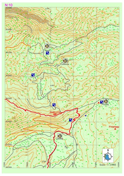
Çukurbağ – Pınarbaşı
The road which goes among the thorns in some places until Phellos had become extremely non-visible at some points due to the new road construction works. After a gentle slope towards the hill, the ruins of Phellos can be seen and the n the pathway takes us towards the entrance of the city. It turns towards Çukurbağa without entering into the city. It then continues to descend perpendicular to Çukurbağ for a couple of kilometers. From the village mosque one could reach to village center.
There are no markets in the village but there are drinking water wells in multiple locations. Lycian road goes inside of Çukurbağ and after passing long flat areas and fields reaches to a point overlooking Kaş district from a hill. The ruins registered with the name of Pınarbaşı at southern together with Pınarbaşı settlement without leaving from the road when descending towards Çukurbağ down from Phellos.
PHELLOS
Phellos city is located on a hill of 550m length and 200m width in the Felen area in Çukurbağ village at 950m of height from the sea level, northeast of Kaş (Antiphellos). The history of the settlement dates back towards 6-7th centuries B.C. Its name in Lycian language is “Vehinda”. Phellos is a military settlement controlling the whole region rather than a big town and Antiphellos is the port of this settlement. The richness of the city comes from the income of cedar forests. The parapets surrounding the acropolis are supported with towers in east and southeast direction. Among many sarcophaguses located inside the valley in the north of acropolis and at the slopes of the hill across, the one with the reliefs dated back to 385-350 B.C. is the one which gets the most attention. On the one side of this sarcophagus there is the depiction of its owner lying on a sofa holding a cup. There are two figures standing at the both sides of the dead and bird figures beneath the sofa. In this section there are other sarcophaguses belonging to 4th century B.C. which also have inscriptions on them. Towards the west end of the acropolis there are home type Lycia rock tombs. This is one of the most authentic examples of the reflection of the wooden house architecture on rock tombs and there are Klines on the three sides of the tomb room.


PINARBAŞI SETTLEMENT AREA
Some part of the settlement area is located 500m southeast and some part of it is located 250m east of Meşelik hill at the Pınarbaşı village. The building which is seen first is a building probably built as a lime stone tower with its wall masonry of rubble stone in rectangular plan in an area of slightly hill-like. When continued from this structure to Meşelik hill, there are demolished ruins of a structure of which plan cannot be comprehended due to the dense vegetation and one well cistern. At the west of these there are ruins of a building on which yard contains a well cistern and it is surrounded by a yard wall.