
Simena – Kapaklı – Andriake
The road advancing from between the houses behind the square of the Üçağız location leads to the dockyard after 2-3km of earth road. The road winding along the coast where the dockyard is located advances across the plains where there are only a few houses, fields and a cemetery and a water fountain. After reaching the cove, the road splits up from the cove by passing through the ruins overlooking the cove.
Lycia road path advances with a slight upward slope until Kapaklı village, but without entering the residential region, the road starts to re-descend from below the village and reaches the sea cost. You can reach Andriake from the gravelous beach and you can get to the highway if you take the narrow pathway to the right after passing by firstly the wooden bridge and then the archeological settings in Andriake. From this place, you can catch a sight of the St. Nicholaos Church in the district of Demre and then get to Myra archeological settings.
If you take the turn left from the gravelous beach and not the turn right, the road advances parallel to the mount where the Sura archeological settings are located and along the slopes opposite to the valley only to head to Gürses.
As the region is close to the center of the Lycia civilization where the archeological settings are dense, the ruins in the vicinity are worth seeing after sheering of the designated road of Lycia. Especially after Üçyağız, along the cove where the dockyard is located, you can catch a sight of Simena by taking the pathway advancing to the mount in the south, see seaside Erenyeri, Kişneliada, Aşırlıada after a few kilometers after the plains of the dockyard and by taking the turn left from the same spot, you can visit first the İnişdibi settlement and then Hoyran, Divle, İkizkilise and Istlada archeological settings which is right above the Lycia road.


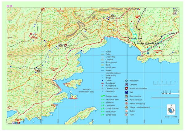
ANDRIAKE
The Lycia shore is a rocky terrain. This topography lets a dockyard to be established only in some areas. As the capability to make use of the sea is vital in that area, many dockyards have developed and gained importance in their vicinities. And Andriake which is 4.5 km southwest of Myra is the harbor settlement of Myra that has developed in this sense.
Andriake city history is in concurrence with the histories of Lycia and Myra. The harbor structures and monuments of commendation in Andriake demonstrate that Myra has maintained its importance through the Helenistic period. The epigraph of Lycian League Customs Law erected in Andriake during this period also emphasizes the importance of harbor.
After stopping by Myra during his third missionary travel in the years of 53-57, St. Paulus has ben transferred to a ship carrying grain from Andriake to Rome while he was heading to Rome as a prisoner in order to give an account of the discontent he caused in Jerusalem during the years of 60-61,
Hadrianic Period has been the most intense reconstruction period of Andriake. The sheltered docks of Andriake, located on the sea route from east to west in the Mediterranean, and Patara have played a great part in the protection and safe transportation of the grain which was exported from Egypt by the empire.
With the announcement of Myra as the capital of Lycia in the 5th century, Andriake has become the main harbor of the regional metropolis. Gaining much more importance during the period of Justinian I, Andriake has been badly influenced by the Arabian raids, alluvial deposit at the harbor and the damage caused by the incessant earthquakes and it has been abandoned to a great extent.
Ruins of Andriake are spread to the north, south and east of the inner harbor. Granarium and Agora at the east entrance have been built on the most spacious plain of the south slope of the city. Granarium, Agora, 4 churches, 1 synagogue, 2 bathhouses, cisterns, storehouses and shops and many more unidentified structure ruins are present in this area.
The area between the Granarium and the harbor have been made fit for housing by terracing.
The streets sweeping along the pier boulevard constitute the wards. Andriake Mercantile Agora is known with the adopted name Plakoma by the first travelers of the region and which is also depicted in the ancient resources. It is situated on an area of 60×40 meters. A plan in the “U” shape form has been achieved with the shops surrounding the underground cistern from the east, north and west in the center of Agora. There is a monumental gateway in the north front. The cistern at the center of the agora has also been used as infrastructure. The arches are relatively in good shape. It is approximately 24×12 m in size. The arches have been covered with layed flagstones. The stones covering the cistern also constitute the avenue of the agora.
One of the most interesting localities of Andriake are the workshops which operated south of the north gateway of the Plakoma where the purple fabric dye was manufactured from the crustacean molluscs called Murexes. The color used in the fabric dying is procured by furnacing and, through the release of the mucus into the air, oxidation of the mucus which can found in the glands of these murex type molluscs. While the shells of the used murexes have been thrown into the sea in Aperlai, they have been piled up in the east and west parts of the Agora in Andriake. These piles shaped as mounts partly up to 3 meters contain approximately 400-800 meters cube sea shells. These wastes have been used in the structures as murex mortar by mixing with lime mortar.
Granarium, which is the most glamorous and most preserved structure of Andriake harbor settlement, consists of 8 sections and is about 2300m2 wide with the measures of 64×40 meters. There are artisan or workshop markings that consist of few letters on the surfaces of the blocks. The sections are interconnected with the inner doors. The effigies of the Emperor Hadrian and his wife Sabina is engraved above the middle entrance door. There is an inscription of dedication on the structure. This inscription of dedication and the hair style of Sabina’s effigy reinforce the estimations regarding the completion of the structure to be around the years of 129-130. The marks surviving until today indicate that the structure had been covered with a wooden roof.
Granariums constructed in Patara and Andriake indicate the confidence of Roman Empire in these aforementioned cities. The grain has been preserved and stored in these huge silos. The most glamorous structure of the ancient city, today, the Granarium has been invigorated as a museum bearing the name of the Lycian region to which once it served as the capital city in ancient times.
The type of the tomb in the center of the city necropolis being sarcophagus, the necropolis is located on the ridges where the city stands upon. Ruins of a synagogue were encountered in the west corner of the Granarium during the excavations carried out in the city. The 5th century dated structure is a harbor synagogue serving both for the Jewish community in the harbor and for the use by the Jewish visiting the harbor for trade. There are a total of 6 churches, the 2 being in the north settlement and 4 being in south settlement of Andriake.
Abscenece of baptisteries in the churches indicate that they were constructed to serve for the religious needs of the visitors of the harbor rather than for the community living in Myra and Andriake. As a result of the Andriake harbor losing its importance and being filled with sand, probably 655 years later, Taşdibi locality, with the name Stamira, was deployed as the harbor of the city. The ruins of a Seljukian structure at the cape sand which also served as a lighthouse has been called as The Pirgos Castle until 1800s.
HOYRAN (SOROUDA)
The city, as a small Lycian settlement surrounded by city walls, overlooking Üçağız from the top of Mount Esseler, has been a location of settlement from The Classical Era to The Byzantine Period. Both with its striking scenery and with its interesting ruins of tombs, Horan is the most impressive of all the small sized cities of Lycia. It has a special place in the world of archeology due to the embossed tombs named the “Hoyran Mausoleum”. The hill the city is located on, overviews Andriake, Kekova, Aşırlı Adası, Simena, Theimussa and Istlada.
When entered to the town of Kyaneai, one comes across the tomb which can be recognized to belong to the “Son of Ta” by virtue of the inscription together with various figures and depictions and where there are no other ruins around.
There is the chamber tomb of Tlepolemos, the ruler of the city, which overlooks the rocky mountain against the tomb and which is considered to date back to the Hellenistic period. There are dwellings and cisterns on the rocks west of the tomb. The end to the ruins in this section are the Lycian domestic type tombs at the very edge.The main settlement area can be reached passing by today’s Hoyran Village south of the ruins belonging to the first settlements of the city. One first comes across Lycian type rock-cut tombs.There are sarcophagi along the graded pathway going up. At the end of the plain which the pathway leads to, there are rock-cut tombs, sarcophagi and a pillar tomb with a woman figure embossment.There are various depictions embossed on the frontsurface of one of the rock-cut tombs. Due to the portrayal of birds on the tombs, it is known as the tomb with roosters and pigeons and it dates back to the 4th century BC. Most of the inscribed sarcophagi located in the city belong to the Roman Era. Above the tomb and in the parts of the mount facing the esplanade, one comes across widespread structure ruins. And the entrance to the acropolis is through these rocks.
KİŞNELİ ADASI (ISLAND)
As one of the islands around the region of Kekova island, Kişneli Ada witnessed 5th and 6th century settlements. At the shore to the west of the island, there is a church with the apsides and a part of the tower above it and some parts of the side nave walls still standing. There have been remarks of structure foundations destroyed to the extent that doesn’t allow a plan to be sketched out and two cisterns have been located in the area.
AŞIRLI ADASI (ISLAND)
Aşırlı Adası, located amongst Kekova Adası, Gökliman and Kamışlık location, is amongst the important coastal towns of the Lycian League and is in the position of a military settlement providing transportation and communication between the cities. Its longest distance is 1200m from east to west and the widest distance is 600m from north to south and it is in the midst of the sea route from Çayağzı location to Kale and Üçağız. Transportation is carried out through these centers. There is a cove in the south and a small transportation worthy to the north of the island which has an indented coastline with steep slopes.
Andriake
SURA
Just behind Andriake, Sura, known as the Apollo prophecy center of Myre and nearby settlements, is a small place of settlement and it is known to be called “Surezi” in the earlier periods. There is 650m2 size Bey Konağı (Mansion) used also as Acropolis on the rocky mountain overlooking the deep Apollo valley on the west. There are 6 domestic type tombs beside the dispersed sarcophagi to the east and south of the Acropolis escarpment. The sarcophagus underlying the mauseleum is the biggest sarcophagus of Lycia. Sura is also famous for this mausoleum along with its Apollo sophism. The front yard of the mausoleum which can be understood to have had belonged to someone named Miszretije had been used as an outdoor area of worshiping. Then names of the Apollo Surius priests are listed on the rock stelas in the worshiping area.
The only pathway trackable on the surface is the stepped pathway starting from the Priests area and ending at the Temple of Apollo.
Located at the coastline during the ancient times, Apollo Oracular Temple is presently on the brink of a swamp as the stream has filled the valley. The spring water to the east of the temple is still running. It is regarded as the spring to have filled the oracular shrine of the Apollo Oracle Center. On the inner walls of the temple, the names of the benefactors are listed. There are detailed depictions regarding the prophecy in ancient sources. According to this, people who want to learn about their future come to the shrine with presents of meat and bread, number of fish appear in the shrine and the Oracle anticipates the future according to the types of the fish. Besides, if the fish accept the meat thrown to them it’s good and if they refuse it bears a bad interpretation. The Byzantium Church established where the Apollo Oracular Temple is, has been used until the Middle Ages thanks to the faith and worshiping habits of the local community.
SİMENA (KALE)
Dating back to 4th century, the city is established on a rocky peninsula. Along with Apollonia, İsinda nd Aperlai, it is represented in the Lycian League. The ruins of the dwellings on the north slope of the rocky hill are located in the oldest, dating back to the Classical era, settlement area of the city which hosts city walls of Hellenistic period, structures that belong to the Roman period and a castle of Byzantium period. The harbor neighborhood of the city is the part which was submerged and that became an island due to the earthquakes. The pier underwater and many structure ruins can be observed.
On the island, there are sizable cisterns built to meet the water needs of the ships berthing, places for port administration and commercial activities. “Presented to Emperor Titus as a gift by the citizens and senates of Aperlai and other cities of the Lycian League” is inscribed on the bathhouse epigraph which dates back to the second half of the 1st century and is located on the coast at the slope of the Ortaçağ Kalesi (Middle Ages Castle) which has been placed on the early Acropolis city walls. The slope ascending from the shore up to the Acropolis is the place where residential and public structures are located. There are sarcophagi along the exit pathway.
The biggest structure prior reaching the city walls, is the structure of a church built on the temple and which is used as a mosque lately. Above the church, there is a small 7 step amphitheater with 200 people capacity and having a fine view of Kekova and which belongs to the Hellenistic Period. There are many sarcophagi around and in the water apart from the rock-cut tombs with epigraphs in Lycian that can be found in a passage leading to the Acropolis rocks.